Project Geodatabase Layout
The GeoSWMM project geodatabase has a standard data structure. It consists of two types of datasets:
-
Feature Class and
-
Table.
When a new GeoSWMM project geodatabase is created, it appears in ArcGIS Pro map TOC with the feature class layers only. These feature classes represent the visual objects (e.g. conduits) of a SWMM model. On the other hand, the tables are associated with either visual object properties or non-visual object (e.g. land use) model data. The Reload (
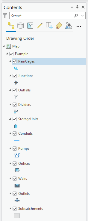
The GeoSWMM project geodatabase opens in the TOC of ArcGIS Pro map with the following visual object feature classes as shown in Fig. 60. The lists of available data components in the geodatabase have also been provided in Table 9 and Table 10.

Fig.60: GeoSWMM database feature classes
Table 9: GeoSWMM Database feature class components
Feature Class Name | Data Type | Associated Visual Object in GeoSWMM |
|---|---|---|
RainGages | Point Feature Class | Rain Gage |
Junctions | Point Feature Class | Junction |
Outfalls | Point Feature Class | Outfall |
Dividers | Point Feature Class | Divider |
StorageUnits | Point Feature Class | Storage Unit |
Conduits | Line Feature Class | Conduit |
Pumps | Line Feature Class | Pump |
Orifices | Line Feature Class | Orifice |
Weirs | Line Feature Class | Weir |
Outlets | Line Feature Class | Outlet |
Subcatchments | Polygon Feature Class | Subcatchment |
Table 10: GeoSWMM Database tables
SWMM Object Category | Table Name | Associated SWMM Component Name |
|---|---|---|
Visual | AttributeMapping | All (rain gage, subcatchment, node, and link) |
Infiltration | Nodes | |
InflowDirect | Nodes | |
InflowDryWeather | Nodes | |
InflowRDII | Nodes | |
LIDUsageSettings | Subcatchments | |
SubcatchmentInitialBuildup | Subcatchments | |
SubcatchmentsLandUses | Subcatchments | |
Treatments | Nodes | |
Non-visual | Aquifers | Aquifers |
Buildup | Land Uses | |
Config | Project Defaults | |
Controls | Controls | |
CurveDefinitions | Curves | |
CurveValues | Curves | |
HydrographData | Unit Hydrographs | |
LandUses | Land Uses | |
LIDControlPavement | LID Controls | |
LIDControls | LID Controls | |
LIDControlSoil | LID Controls | |
LIDControlStorage | LID Controls | |
LIDControlSurface | LID Controls | |
LIDControlUnderdrain | LID Controls | |
Pollutants | Pollutants | |
SnowPackParameters | Snow Packs | |
SnowPacks | Snow Packs | |
TimePatternMultipliersData | Time Patterns | |
TimePatterns | Time Patterns | |
TimeSeries | Time Series | |
TimeSeriesData | Time Series | |
Transects | Transects | |
TransectStationElevations | Transects | |
UnitHydrographs | Unit Hydrographs | |
Washoff | Land Uses | |
Other | VersionChecker | ... |
