File Geodatabase (Geodatabase) for GeoSWMM Project
When a user creates a new project in GeoSWMM, all of the types of default GIS layers are generated within a file geodatabase. A file geodatabase is a collection of files in a folder on disk that can store, query and manage both spatial and non-spatial data. Several users can use the same file geodatabase simultaneously, but only one user at a time can edit the same set of data. Multiple users can edit a file geodatabase, but they must be editing different data.
File geodatabases are made up of seven system tables plus user data. User data can be stored in the following types of datasets:
- Feature class
- Feature dataset
- Mosaic dataset
- Raster catalog
- Raster dataset
- Schematic dataset
- Table (non-spatial)
- Toolboxes
Feature datasets can contain feature classes as well as the following types of datasets:
- Parcel fabrics
- Feature-linked annotation
- Geometric networks
- Network datasets
- Relationship classes
- Terrains
- Topologies
Users can store any size of data in this geodatabase. The default maximum size of datasets in file geodatabases is 1 TB. The maximum size can be increased to 256 TB for large datasets. File geodatabase size and name limits are as follows:
- File geodatabase size: No limit
- Table or feature class size: 1 TB (default), 4 GB or 256 TB with a keyword
- Number of feature classes and tables: 2,147,483,647
- Number of fields in a feature class or table: 65,534
- Number of rows in a feature class or table: 4,294,967,295
- Geodatabase name length: Number of characters the operating system allows in a folder name
- Feature class or table name length: 160 characters
- Field name length: 64 characters
- Text field width: 2,147,483,647
It is a great advantage for a user to be able to edit any complex or special data using the ArcGIS Pro catalog. The reload operation of a GeoSWMM project geodatabase can be used to update the corresponding SWMM project.
Creating a GeoSWMM Project Geodatabase in Arcgis Pro Map
A user can easily create a GeoSWMM project geodatabase if the GeoSWMM add-in is installed in their ArcGIS Pro. The GeoSWMM add-in tab allows the user to create or open any new or existing SWMM geodatabase (see Project Setup in GeoSWMM). Note that the Map file in ArcGIS Pro must have a proper coordinate system present in its data frame in order to create a GeoSWMM project geodatabase. A user may create or open multiple GeoSWMM geodatabases in the same project but GeoSWMM only allows the user to work on a single SWMM model at a time. In the case of multiple GeoSWMM project geodatabases with different projection systems, the model may often produce erroneous computation results and therefore it is strongly recommended that GeoSWMM users maintain consistency of the coordinate system of GeoSWMM projects and the ArcGIS Pro map data frame.
Although it has been already demonstrated how to create a GeoSWMM project geodatabase in the Quick Start Tutorial chapter of this manual, the general steps of this process are reiterated here for convenience. It is assumed that the Map file in ArcGIS Pro data frame has an appropriate coordinate system present prior to creating a new GeoSWMM project.
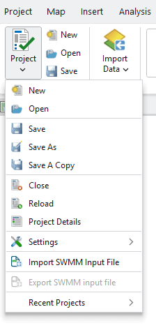
Go to the GeoSWMM tab. Click on Project menu and it will display the items as shown in the following Figure 4.1.
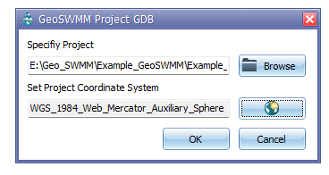
Click on New. A file name assigning dialog box will appear like the following Figure 4.2. Enter the directory and the GeoSWMM project name with a .gdb geodatabase extension. You can also specify the file name and location using browse. Set appropriate project coordinate system. After entering an appropriate file name with directory and project coordinate system, click OK to exit from the window.
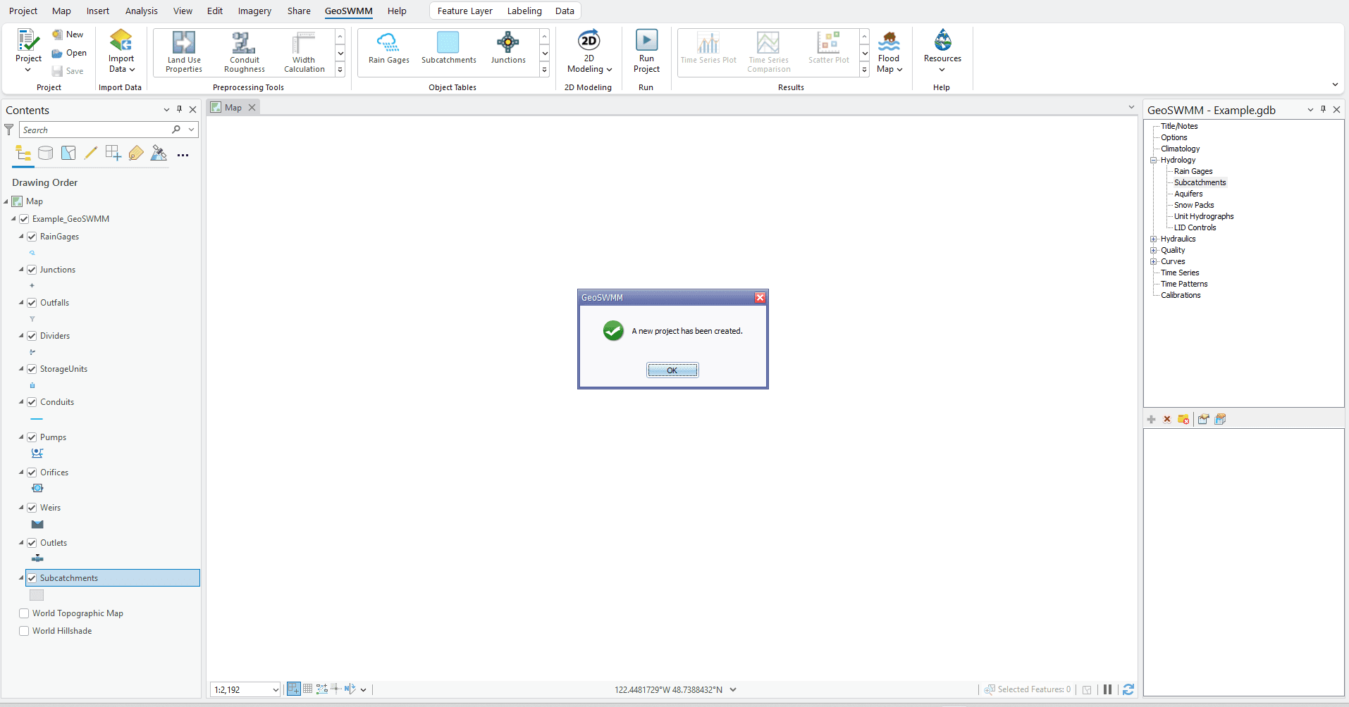
It only takes a few moments to create the GeoSWMM project geodatabase and to open it in ArcGIS Pro map. Notice that the geodatabase is created with a set of feature classes that are displayed in the TOC of ArcGIS Pro (Figure 4.3). The GeoSWMM Object Panel will also appear in ArcGIS Pro map. A notification will display if the geodatabase is created and opened in ArcGIS Pro map successfully. Now you can start model building in GeoSWMM.
Project Geodatabase Layout
The GeoSWMM project geodatabase has a standard data structure. It consists of two types of datasets:
1) Feature Class and
2) Table.
When a new GeoSWMM project geodatabase is created, it appears in ArcGIS Pro map TOC with the feature class layers only. These feature classes represent the visual objects (e.g. conduits) of a SWMM model. On the other hand, the tables are associated with either visual object properties or non-visual object (e.g. land use) model data. The Reload (![]() ) button on the GeoSWMM tab transfers geodatabase information to the SWMM model components. Detailed SWMM database contents can be viewed, edited, and managed using ArcCatalog; however, any user specific modification in the database feature classes or tables may corrupt the GeoSWMM project structure resulting in an invalid geodatabase for the SWMM model.
) button on the GeoSWMM tab transfers geodatabase information to the SWMM model components. Detailed SWMM database contents can be viewed, edited, and managed using ArcCatalog; however, any user specific modification in the database feature classes or tables may corrupt the GeoSWMM project structure resulting in an invalid geodatabase for the SWMM model.
The GeoSWMM project geodatabase opens in the TOC of ArcGIS Pro map with the following visual object feature classes as shown in Figure 4.4. The lists of available data components in the geodatabase have also been provided in Table 4.1 and Table 4.2 .
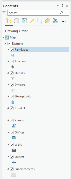
Table 4.1 : GeoSWMM Database feature class components
Feature Class Name | Data Type | Associated Visual Object in GeoSWMM |
|---|---|---|
RainGages | Point Feature Class | Rain Gage |
Junctions | Point Feature Class | Junction |
Outfalls | Point Feature Class | Outfall |
Dividers | Point Feature Class | Divider |
StorageUnits | Point Feature Class | Storage Unit |
Conduits | Line Feature Class | Conduit |
Pumps | Line Feature Class | Pump |
Orifices | Line Feature Class | Orifice |
Weirs | Line Feature Class | Weir |
Outlets | Line Feature Class | Outlet |
Subcatchments | Polygon Feature Class | Subcatchment |
Table 4.2 : GeoSWMM Database Tables
SWMM Object Category | Table Name | Associated SWMM Component Name |
|---|---|---|
Visual | AttributeMapping | All (rain gage, subcatchment, node, and link) |
Infiltration | Nodes | |
InflowDirect | Nodes | |
InflowDryWeather | Nodes | |
InflowRDII | Nodes | |
LIDUsageSettings | Subcatchments | |
SubcatchmentInitialBuildup | Subcatchments | |
SubcatchmentsLandUses | Subcatchments | |
Treatments | Nodes | |
Non-visual | Aquifers | Aquifers |
Buildup | Land Uses | |
Config | Project Defaults | |
Controls | Controls | |
CurveDefinitions | Curves | |
CurveValues | Curves | |
HydrographData | Unit Hydrographs | |
LandUses | Land Uses | |
LIDControlPavement | LID Controls | |
LIDControls | LID Controls | |
LIDControlSoil | LID Controls | |
LIDControlStorage | LID Controls | |
LIDControlSurface | LID Controls | |
LIDControlUnderdrain | LID Controls | |
Pollutants | Pollutants | |
SnowPackParameters | Snow Packs | |
SnowPacks | Snow Packs | |
TimePatternMultipliersData | Time Patterns | |
TimePatterns | Time Patterns | |
TimeSeries | Time Series | |
TimeSeriesData | Time Series | |
Transects | Transects | |
TransectStationElevations | Transects | |
UnitHydrographs | Unit Hydrographs | |
Washoff | Land Uses | |
Other | VersionChecker |