Unit Hydrographs
Unit Hydrographs (UHs) estimate rainfall-dependent infiltration/inflow (RDII) into a sewer system. A UH set contains up to three such hydrographs, one for a short-term response, one for an intermediate-term response, and one for a long-term response. A UH group can have up to 12 UH sets, one for each month of the year. Each UH group is considered as a separate object by GeoSWMM, and is assigned its own unique name along with the name of the rain gage that supplies rainfall data to it.
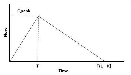
Each unit hydrograph, as shown in Fig. 51, is defined by three parameters:
-
R: the fraction of rainfall volume that enters the sewer system
-
T: the time from the onset of rainfall to the peak of the UH in hours
-
K: the ratio of time to recession of the UH to the time to peak

Fig.51: An RDII Unit Hydrograph (Source: User Manual for EPA-SWMM 5.1)
Each unit hydrograph can also have a set of Initial Abstraction (IA) parameters associated with it. These determine how much rainfall is lost to interception and depression storage before any excess rainfall is generated and transformed into RDII flow by the hydrograph. The IA parameters consist of:
-
A maximum possible depth of IA (inches or mm)
-
A recovery rate (inches/day or mm/day) at which stored IA is depleted during dry periods
-
An initial depth of stored IA (inches or mm)
To generate RDII into a drainage system node, the node must identify (through its Inflows property) the UH group and the area of the surrounding sewer shed that contributes RDII flow.
-
An alternative to using unit hydrographs to define RDII flow is to create an external RDII interface file, which contains RDII time series data.
-
Unit hydrographs could also be used to replace GeoSWMM’s main rainfall-runoff process that uses Subcatchment objects, provided that properly calibrated UHs are utilized. In this case what GeoSWMM calls RDII inflow to a node would actually represent overland runoff.
