Creating 2D Layers
The Create 2D Layer tool automatically creates features in the 2D network, including Junctions 2D, Conduits 2D, and Cells 2D, taking into account obstructions, boundary layer extent, and generated 2D nodes. The 2D mesh is formed through rectangular open conduits between all adjacent cells. The tool also populates the required attributes of the 2D conduits, e.g., length, width, roughness.
All the required layers to generate 2D mesh will be assigned automatically from project details, as they are already mapped from the Create 2D Nodes tool. You need to select the source from where junction’s invert elevation will be calculated.
The characteristics of required input features in the Create 2D Layers tool are described below.
Bank Line
Bank Lines are used to define the main channel banks for a cross section. You can import Bank Lines from either a) The ArcGIS TOC panel through the dropdown option, or b) browse and add one or more polygon layers through the browse icon. The layer will be saved in the project database. This option will remain inactive (by default) for this version of GeoSWMM 2D.
2D Nodes
2D nodes represent center points that will be used to create the subsequent 2D conduit and 2D cell layers. The 2D nodes layer will be directly assigned in the “2D Layer Creation” tool from project GDB.
Elevation Data
When generating the 2D layer, the model will extract elevations from either the DEM layer at the locations of the 2D nodes or directly from the 2D Nodes created through the Create 2D Nodes tool.


Fig.160: Create 2D Layers Tool option in 2D Modeling
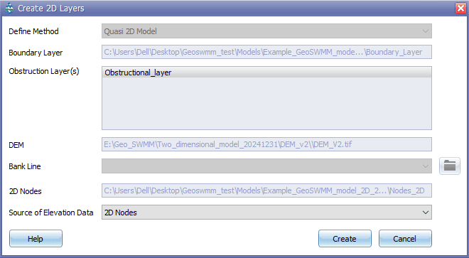
The interface of this tool looks like the following:

Fig.161: Create 2D Nodes Tool window
Steps:
-
Define Method from dropdown for 2D Layers generation.
-
Boundary Layer will be directly assigned from the Boundary Definition tool where the layer is saved in the project geodatabase.
-
Obstruction Layer directory, saved in the project details during creation of 2D nodes, will be directly assigned to the “Create 2D Layers” tool.
-
The DEM layer directory, saved in the project details during creation of 2D nodes, will be directly assigned to the “Create 2D Layers” tool.
-
Bank Line option will remain inactive (by default) for this GeoSWMM 2D release.
-
2D Nodes layer will be directly assigned in the Create 2D Layers tool from the project GDB.
-
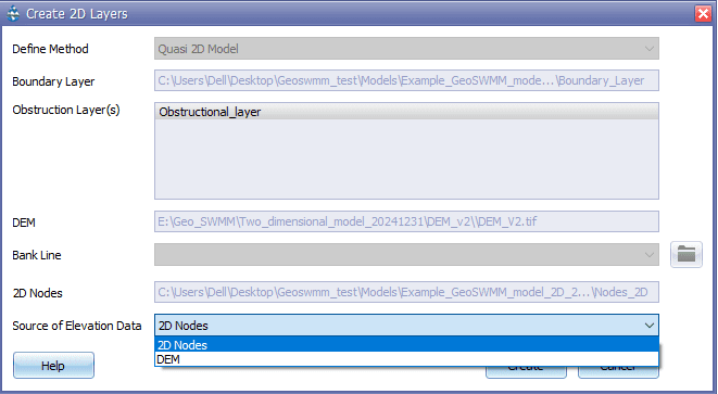
You can assign the source for elevation data from:
a) Digital Elevation Model (DEM)
b) 2D Nodes Layer

Fig.162: Source of Elevation Data assignment
- Click “Create 2D Layers” to generate the 2D Layers.
