Flood Mapping Tool
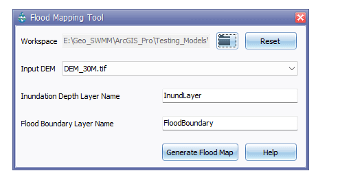
After a successful simulation of the model, the Flood Mapping Tool generates a dimensional flood boundary within the subcatchment. Flood Mapping Tool primarily works with the Digital Elevation Model (DEM) layer and simulated water surface elevation (WSEL) of the junction layer. The tool calculates flood depth by subtracting the simulated water surface elevation value from the Digital Elevation Model (DEM) dataset.

Fig. 112: Flood Mapping Tool window
The Flood Mapping Tool manages GIS datasets in a geodatabase while performing the user assigned tasks. This tool allows users to process DEM data, create and manage the Inundation Depth layer and Flood boundary layer. When the (
There are two major functional segments in the tool interface such as:
-
Workspace and raw DEM (Primary input)
-
Specifying Inundation Depth Layer name and Flood Boundary Layer name
Primary Input

Fig.113: The Primary input in Flood Mapping Tool
When launched, the Flood Mapping Tool requires the user to set a geodatabase name where it will manage and store the processed flood map extent. In addition, the user will need to provide a DEM raster or grid data that represents the topography of the project area. Note that the input DEM must have linear units to generate flood boundaries accurately.
Final Component

Fig.114: Defining layers’ name in Flood Mapping Tool
The second component in the interface enables the user to generate the flood map.
Inundation Depth Layer Name is a name field that represents the name of the inundation depth obtained by subtracting the water surface elevation layer (WSEL) from the digital elevation model (DEM).
Flood Boundary Layer Name is a name field that represents the name of the generated flood area boundary.
