Land Use/Land Cover Properties Tool
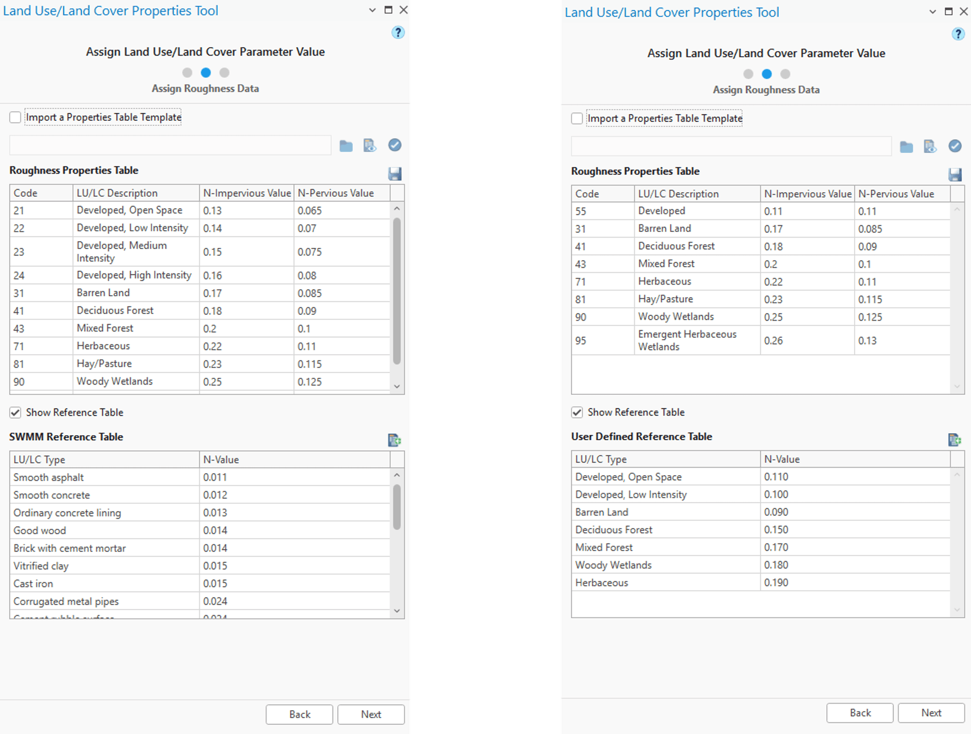
The surface roughness of a subcatchment affects the overland flow during a runoff event. GeoSWMM uses the Manning’s roughness coefficient (Manning's N or N-value) when computing the overland flow rate. This roughness coefficient varies for different types of land use and land cover (LU/LC). Moreover, they are not same for the impervious and pervious areas. Generally, the impervious areas have a lower N-value than pervious areas (e.g. 0.011 for smooth asphalt versus 0.24 for dense grass).
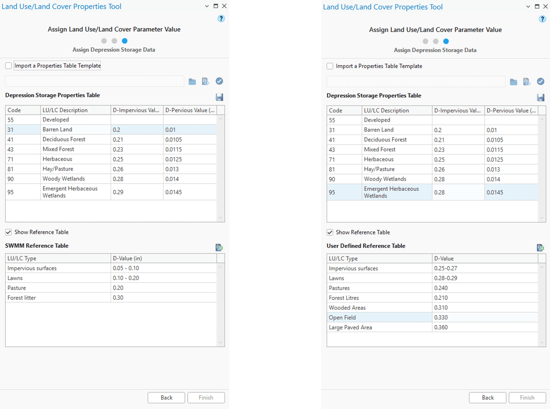
Depression Storage is another special characteristic of a subcatchment that represents surface storage provided by ponding, surface wetting, and interception; it is expressed as the depth of the water. Surface runoff accumulates over a subcatchment surface only after the water depth exceeds the value of maximum depression storage. It represents the volume of water filled prior to the occurrence of surface runoff. The value of the depth of the maximum depression storage (D-value) varies from impervious to pervious areas (e.g. 0.05 for impervious surfaces whereas 0.30 for forest areas).
The "Land Use/Land Cover Properties Tool" is a pre-processing tool in GeoSWMM that enables the user to efficiently handle the land use data for their SWMM project. It provides comprehensive options to reclassify reference LU/LC data (e.g. the USGS NLCD 2011 land cover data) to the simplified LU/LC types that are representative of the model subcatchments. In addition, it allows the user to assign suitable values for the Manning's N and the depth of the maximum depression storage for each land use type. Finally, the tool calculates the area-weighted N and D values for each subcatchment and stores the results in an attribute column in the subcatchment layer and corresponding model database.
The tool works primarily in three steps:
- Reclassify existing or source LU/LC data
- Assigning N-values to the reclassified LU/LC types
- Assigning D-values to the reclassified LU/LC types
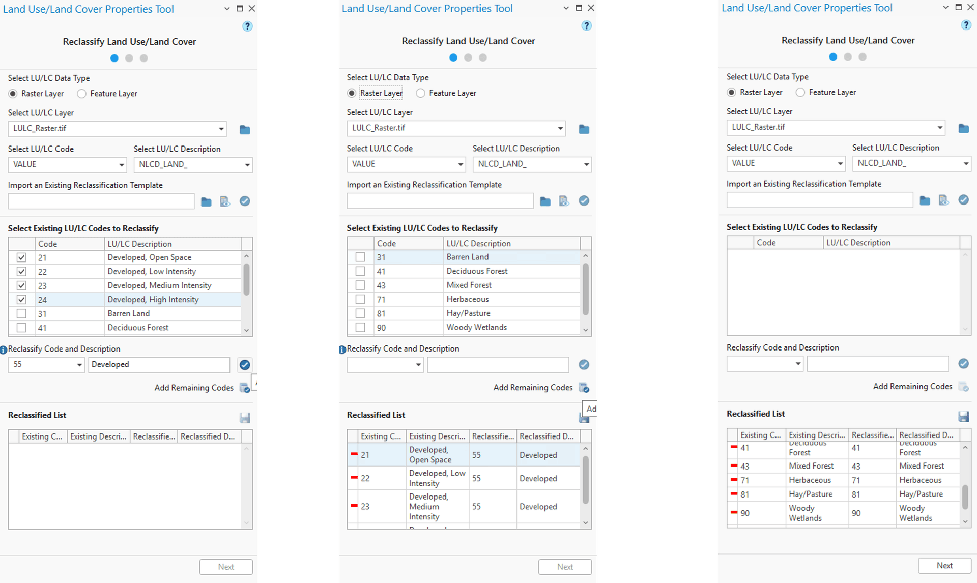
Reclassify Land Use/Land Cover:
Select LU/LC Data Type:
There is an option to choose Land Use/Land Cover data type using a radio button to choose between ‘Raster Layer’ or ‘Feature Layer’ for LU/LC reclassification.
Select LU/LC Layer:
LU/LC layer can be chosen from map layers or can be added to the tool by browsing any valid file path (![]() ).
).
Select LU/LC Code and Description:
The LU/LC code and description can be chosen from the dropdown where the selected LU/LC layer’s attributes will be available for field mapping. If there are no attribute for description in the data, user needs to select ‘No field’ from the dropdown. After choosing the fields, a table below named “Select Existing LU/LC Code to Reclassify” will be populated.
Re-Classification can be done in two different ways with this tool, which are:
- By Importing a Reclassification Template
- By manually selecting from Existing LU/LC Code
Import An Existing Reclassification Template:
User can browse (![]() ) their computer to import an existing reclassification template. View (
) their computer to import an existing reclassification template. View (![]() ) button will show the loaded reclassification template. If Apply (
) button will show the loaded reclassification template. If Apply (![]() ) button is clicked, then the code and description rows that match with Existing LU/LC Code and Description rows will be reclassified following the template and will be transferred to the “Reclassified list”. Code and description row without a match will remain unchanged. Rest of the code and description from the existing LU/LC code can be added to reclassified list upon user demand by Add Remaining Codes (
) button is clicked, then the code and description rows that match with Existing LU/LC Code and Description rows will be reclassified following the template and will be transferred to the “Reclassified list”. Code and description row without a match will remain unchanged. Rest of the code and description from the existing LU/LC code can be added to reclassified list upon user demand by Add Remaining Codes (![]() ) button. Detailed land use reclassification template file formats are provided in Appendix E.1.
) button. Detailed land use reclassification template file formats are provided in Appendix E.1.
Selecting from Existing LU/LC Code to Reclassify:
Using the checkboxes, users need to select the code and description rows that they want to reclassify.
Reclassify Code and Description:
For the selected rows, a new code has to be assigned. This can be done directly by typing in the code or from the suggestions from previously applied codes. For typing in a new code directly, the user will have to type in a description for the new reclassified code. If the user selects a previously entered code or a code from the dropdown menu, the associated description will autofill and will remain non-editable. Apply (![]() ) button will take all the selected items to Reclassified List. It is to note that for each code there should be a unique description. There cannot be any duplication of code or description.
) button will take all the selected items to Reclassified List. It is to note that for each code there should be a unique description. There cannot be any duplication of code or description.
Reclassified list
All the reclassified items either by using a template or by manual reclassification will be displayed here. Users can undo a reclassification by clicking the (-) icon in the Reclassified List table. There is a Save (![]() ) button to save the Reclassified List in CSV format for further use as template.
) button to save the Reclassified List in CSV format for further use as template.
Assign Roughness Data Window:
After moving to this window Manning’s Roughness values (N-values) need to be assigned to the corresponding LU/LC codes and descriptions. There will be two different columns for the pervious and impervious surfaces of the subcatchment.
This can be done in two different ways:
- By importing an existing template
- By assigning manually.
Import a Properties Table Template
After checking the input field user can import a properties table by browsing any file path. View (![]() ) button will show the loaded table with LU/LC code, description and corresponding N-Values. If the Apply (
) button will show the loaded table with LU/LC code, description and corresponding N-Values. If the Apply (![]() ) button is clicked, then N-values will be assigned to the corresponding code and description of Roughness Properties Table that match the template. The blank fields can be filled with help from reference table.
) button is clicked, then N-values will be assigned to the corresponding code and description of Roughness Properties Table that match the template. The blank fields can be filled with help from reference table.
Assigning Roughness Values Manually:
There are two different columns for N-Impervious and N-Pervious values. These can be filled in manually. Users can also get help from the SWMM reference table. Show Reference Table box will be checked and a SWMM Reference Table (Appendix A.6) will be present by default. If the user wants to import a custom reference table, there is an Import a User Defined Reference Table (![]() ) button. It is to note that once the User Defined Table is imported, the SWMM Reference Table will not be visible anymore.
) button. It is to note that once the User Defined Table is imported, the SWMM Reference Table will not be visible anymore.
After successfully assigning roughness values the Roughness Properties Table can be saved in CSV format for later use. (Appendix E.2).
Assign Depression Storage Data Window:
After moving to this window Depression Storage Data (D-values) have to be assigned to corresponding LU/LC codes and descriptions. The unit of D-Values will be in inch or mm depending on the map. There will be two different columns for pervious and impervious surfaces of the subcatchment.
This can be done in two different ways:
- By importing an existing template
- By assigning manually
Import a Properties Table Template
After checking the input field user can import a properties table by browsing any file path. View (![]() ) button will show the loaded table with LU/LC code, description and corresponding D-Values. If Apply (
) button will show the loaded table with LU/LC code, description and corresponding D-Values. If Apply (![]() ) button is clicked, then D-values will be assigned to the corresponding code and description of Depression Storage Table that match the template. The blank fields can be filled taking the help of reference table.
) button is clicked, then D-values will be assigned to the corresponding code and description of Depression Storage Table that match the template. The blank fields can be filled taking the help of reference table.
Assigning Depression Storage Data Manually:
There are two different columns for D-Impervious and D-Pervious values. These can be filled in manually. Users can get help from the reference table. The Show Reference Table box will be checked and a SWMM Reference Table (Appendix A.5) will be present by default. If user wants, there is an Import a User Defined Reference Table (![]() ) button to import a user defined reference table. It is to note that once the user defined table is imported, the SWMM Reference Table won’t be visible anymore.
) button to import a user defined reference table. It is to note that once the user defined table is imported, the SWMM Reference Table won’t be visible anymore.
After successfully assigning roughness values the Depression Storage Properties Table can be saved in CSV format for further use (Appendix E.2).
After assigning all roughness values and depression storage values, if Finish button is clicked, all the Land Use/Land Cover parameters will be calculated following a completion message.